the assumption of responsibility for the welfare of the world
|
STEWARDSHIP the assumption of responsibility for the welfare of the world |
|
SITE MAP
|
REFERENCE BASE
Climate and weather are generally about the same conditions temperature, humidity, precipitation, pressure, wind. But climate is about long-term conditions, while weather is short-term. And climate is often but not always on a broader geographic scale. The most important factor in climate is the amount of energy from sunlight, as determined by latitude. Latitudes nearest the Equator receive sunlight at the highest angles for the longest periods of time, and thus the highest amount of energy. If the Earth were a smooth, dry sphere, latitude alone would determine the amount of energy received by any point on the surface of the Earth. But the Earth is not a smooth, dry sphere, so climate is not determined solely by amount of sunlight. The Earth is covered with two fluids: water and air. And the surface of the Earth, both above and below the ocean, is irregular, higher in some places and lower in others. This irregularity affects the way both the water and the air flow. As the water and air move, they carry the energy around the world, so that the disproportionate energy received in the tropics is to some extent transported to other parts of the world but the movement of energy in water and air is constrained and channeled by the irregular shape of the Earths crust. A central principle of climate change is that global warming, the increase in average global temperature, can lead to varied local climate changes, because disruptions in the energy at any one point will affect other points based on their relative locations in the Earths energy-transfer system.
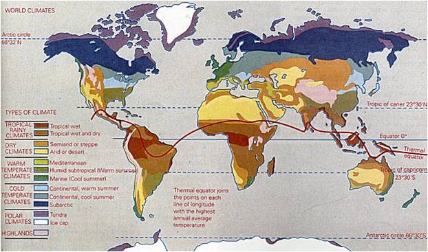
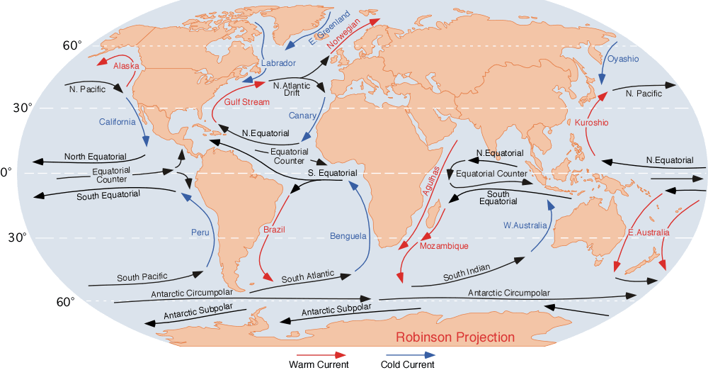
Note the use of the latitudinal terms polar, temperate, and tropical to label the broad climatic regions on this map. As the map shows, the thermal equator the line of highest average temperature doesnt follow the actual Equator. It is distorted, tending to follow the land near the Equator. There are three reasons why the temperature would be higher in general over land rather than water. The first is that water has a very high specific heat. Specific heat is the amount of energy required to raise the temperature of a substance; it takes a lot of energy to raise the temperature of water just a little. The second reason is that the evaporation of water (the change from liquid to gas, a kind of phase transition) uses energy without raising the temperature. The third reason is that land has a higher albedo, or reflectivity, than water. For anything on or over a reflective surface, the effect of direct sunlight, which generally heats things up, is felt twice: once on the way down, and once on the way back up. The primary mechanisms driving the movement that carries energy around the world are the differential heating of the water and air, and the rotation of the Earth. Water (under most circumstances*) and air expand when heated, thus moving a portion of their masses away from the original location (such as the tropics) into adjacent areas, but constrained by the shape of the crust, by the relative high and low points that we observe, for example, in the shape of landmasses. The rotation of the Earth creates an intertial (Coriolis) effect in which, on a smooth crust, surface water and air in the northern hemisphere would rotate clockwise, and surface water and air in the southern hemisphere would rotate counterclockwise, but again these effects are constrained by the shape of the crust.
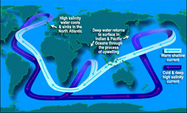
Water also moves up and down within the ocean. Cold water sinks and warm water rises. This dynamic, again coupled with the disproportionate energy received in the tropics and the irregular shape of the Earths crust, gives rise to a second circulatory pattern, known as the oceanic conveyor belt, in which cold, deep water follows one set of paths, is gradually warmed and rises, follows another set of paths on the surface of the ocean, and then is cooled and sinks again.
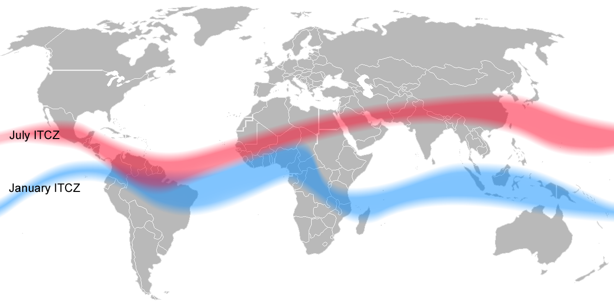
The map below shows the intertropical convergence zone, named for the convergence of winds around the Equator. The ITCZ is actually a fluctuating band of churning air, whose main climate effect is heavy rainfall, particularly where the band is over land. As the map shows, that band is further north during the northern hemispheres summer when the sun is directly over the northern tropics and further south during the southern hemispheres summer when the sun is directly over the southern tropics. The bands shape is similar to the shape of the thermal equator seen on the map above. All of this should make it clear that the ITCZ is driven by solar energy.
The cycling of the ITCZ from north to south is the cause of the distinctive two-season annual cycle in the Tropical Zone: a rainy season when the ITCZ is present, and a dry season when it is not. Elevation, or altitude, has parallels to latitude in its effect on climate. Higher areas tend to be colder, for example. Moving up a mountain side, you would encounter different microclimates in continuous zones, and thus different life. Slope also has an effect on local climate; steep slopes drain better, and thus are drier.
* Water is actually at its densest at 3.98°C (277.13 K), so that water being heated from 0°C to 3.98°C actually contracts. Above 3.98°C, water expands when heated.
© O.T. FORD |
THE STEWARDSHIP Home of the Stewardship Project and O.T. Ford |